 |
||||||||||||||||||||||||||||||||||||
Volume1, Number 12, September, 2011 |
||||||||||||||||||||||||||||||||||||
|
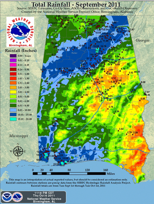
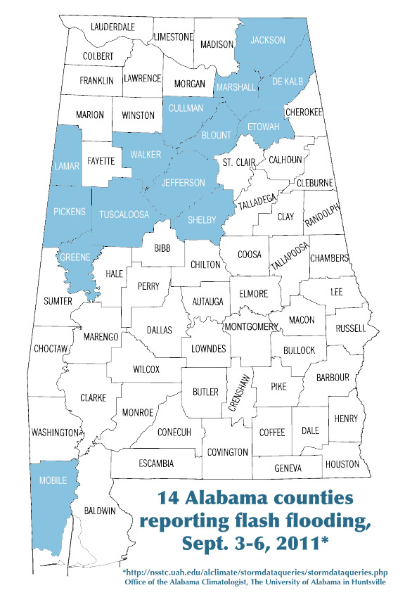
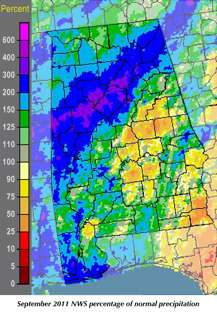
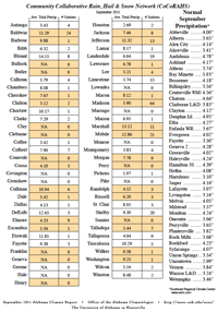
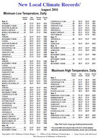
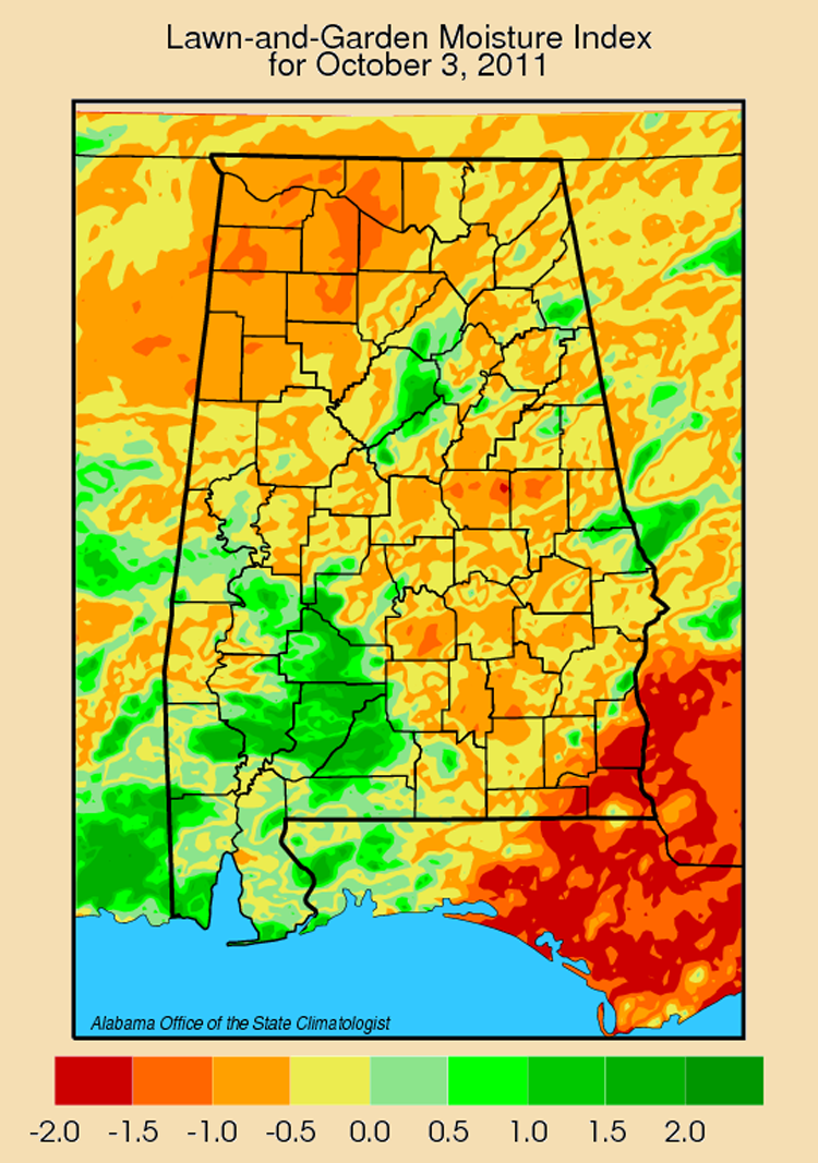
After a summer that was generally warmer and drier than normal, September was a turnaround month for much of Alabama with record setting cool and rain (thanks mostly to tropical storm Lee). Several stations in a swath from Pickens and Greene counties in the southwest to Jackson County in the northeast saw flash flooding and record-setting one-day rainfall as TS Lee washed across the state. Seventeen stations reported their heaviest one-day September rainfall. That included Guntersville, which saw more than ten and a half inches of rain (10.53") on Sept. 5. Scottsboro got more than 9.5 inches and Gadsden 8.79 inches. Fifteen counties reported flash flooding from Sept. 3 to 6. Birmingham, Gadsden, Guntersville, Scottsboro and Valley Head were among the places that had their wettest Septembers on record -- all with more than ten inches of rain for the month. Mobile reported 15.8" of rain for the month, but that is a long way from the 24.13" record set in September 1998 when Hurricane Georges came ashore. Lee's rainfall and what followed were not evenly distributed across the state, however. Dothan had less than half of its normal rain for the month, while Clanton got less than 1.5 inches of rain. While September started hot (Bankhead Lock and Dam started the month with back-to-back record highs of 101° and 102°), that changed with Lee. The statewide mean was more than three degrees cooler than the September norm, with Bessemer seeing its coolest September temperature on record: 36° on Sept. 28. While there have been exceptions, October is generally our "quiet month" in terms of weather. We have had a few bouts of severe October weather in history, but they are generally less frequent and less violent than other months. One of the things we look for in October is the first frost (32°) and the first killing frost (28°) of the fall. If they come too early in the month they can damage crops that haven't been harvested. The Southeastern Regional Climate Center has pulled together historic records that tell us when those frost events have happened in the past, so we can expect when they might happen in the future. The earliest is Valley Head, where there is a 50-50 chance of frost by Oct. 18. Huntsville has a 50% chance by Oct. 27, Birmingham and Montgomery by Nov. 8, and both Auburn and Headland by Nov. 11. Dauphin Island never gets to a 50% chance of frost, although Fairhope has that 50% chance of frost by Nov. 26 and Mobile by Dec. 8. With frost starting in mid-October and spreading south through early December, I suppose in that sense Alabama's climate is just over a month and a half "tall." |
|
||||||||||||||||||||||||||||||||||
| - John Christy | ||||||||||||||||||||||||||||||||||||
|
||||||||||||||||||||||||||||||||||||
 |
||||||||||||||||||||||||||||||||||||
| Copyright (c) 2010-2011 Alabama Office of the State Climatologist. All rights reserved. questions about this web page? Contact webmaster. |
||||||||||||||||||||||||||||||||||||