Daily Vertical Ozone Profiles Launched from the National Weather Service Office, in Old Hickory, TN
Vertical ozone profile surface plots for all ozonesondes launched in Old Hickory for the SOS99 campaign. The figures are available on a (km) altitude scale or a (mbar) altitude scale. The figures are in "pdf" format and can be viewed using the Acrobat Reader. To get your FREE Acrobat reader click the icon below...
![]()
View/Download ozonesonde profiles in PDF form
**Note... There were no launches for 06/20/99 and 07/02/99**
<< previous flight << HYSPLIT Back Trajectories
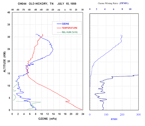
Date [GMT] = 15-07-1999 Time [GMT] = 18:21:38 Location = Old Hickory, TN
Longitude = -86.57 Latitude = 36.25 Launch altitude (km) = 0.181
Burst altitude (km) = 31.087 Burst pressure (mb) = 10.577
Radiation correction = Yes Instrument type = Ozone Sonde
Ozone sonde number = 2Z1273 Total ozone column (Dobson) = 316 (65)
Flow Rate = 28.88 sec/100 ml Lab temp. for flowrate = 18.0
Lab humidity for flowrate = 64% Ozone background = 0.059 (uA)
<< previous flight <<
[ OH015][ OH016 ][ OH017 ][ OH018 ][ OH019 ][ OH020 ][ OH021 ][ OH022 ]
[ OH023 ][ OH024 ][ OH025 ][ OH026 ][ OH027 ][ OH028 ][ OH029 ][ OH030 ]
[ OH031 ][ OH032 ][ OH033 ][ OH034 ][ OH035 ][ OH036 ][ OH037 ][ OH038 ]
[ OH039 ][ OH040 ][ OH041 ][ OH042 ][ OH043 ][ OH044 ]
NOAA - Health of the Atmosphere Program |
This site is maintained by mohammed.ayoub@atmos.uah.edu
Last modified date: September 07, 1999